
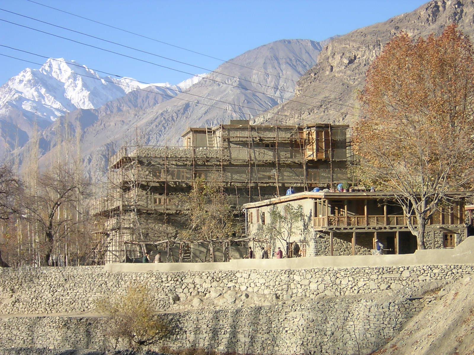
Baltistan
The most remote region of Pakistan. It is situated in the Northern Mountains, at Pamir-Nod, where the Hindu Kush, Pamir, Karakorum, and Himalayan Mountains meet, and where the famed K2 and Nanga Parbat Mountains tower. The Indus River divides Baltistan; in one of the basins created by the river, the old capital city of Skardu is located. Baltistan is commonly known as "Little Tibet." The population of Baltistan is mostly Tibetan-speaking; some of the population have red or blond hair and blue eyes. Baltistan was once a thriving region, thanks to the extensive trade route that linked China and Kashmir. From earliest times, it was in the cultural sphere of northern India. Alexander of Macedon (356–323 BCE) subdued Baltistan and brought Hellenic influence to the area. Thereafter, Baltistan was part of Gandharan culture and was an important center of Buddhism. It was only in the eighth century CE that Tibetan tribes made inroads into the region and became a dominant part of the population.In the thirteenth century, during the rule of the Makpon dynasty, Islam came to Baltistan, and the majority of people converted to the new faith. It is often said that only with the Makpon rulers did Baltistan acquire its identity. Their rule lasted until 1840, when the maharajah Ghulab Singh, the Hindu ruler of Jammu and Kashmir, seized the area. When Pakistan was carved out of western India in 1947, the Muslim majority in Kashmir struggled for freedom from the Hindu Dogra regime, which had ties to India. In 1948, Baltistan became a federally governed area of Pakistan. |

Place of Interest
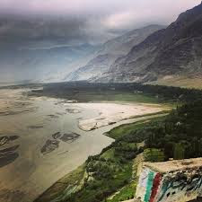
Skardu Valley:
 Skardu is the main town of Baltistan along the wide bank of the
river Indus. Skardu is the largest district of the Northern Areas. Baltistan is
home to some of the highest peaks in the world, the Karakoram Range, Skardu is
very popular with Mountaineering Expeditions. It is equally popular with high
altitude trekkers, who treks to Baltoro Glacier, K2 Base Camp and
Concordia. Skardu by road, lies approximately 5 hours away from Gilgit
and 10 hours drive from Besham. A daily flight to and from Islamabad is also
in operation. The flight is always subject to weather.
Skardu is the main town of Baltistan along the wide bank of the
river Indus. Skardu is the largest district of the Northern Areas. Baltistan is
home to some of the highest peaks in the world, the Karakoram Range, Skardu is
very popular with Mountaineering Expeditions. It is equally popular with high
altitude trekkers, who treks to Baltoro Glacier, K2 Base Camp and
Concordia. Skardu by road, lies approximately 5 hours away from Gilgit
and 10 hours drive from Besham. A daily flight to and from Islamabad is also
in operation. The flight is always subject to weather.
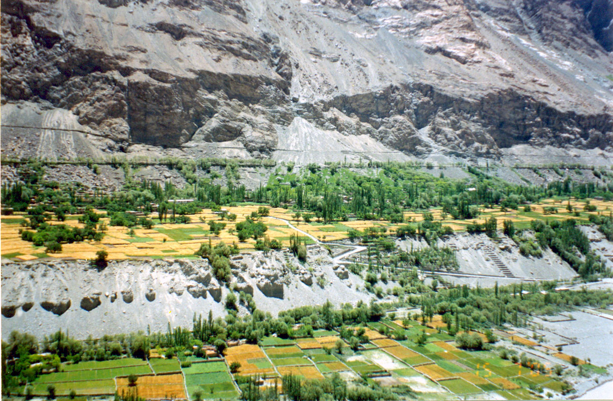
Skardu has a character of its own and has a very interesting
scenery. The Indus becomes wide and still here. The town is surrounded by dry
rugged mountains and sand dunes.
Skardu is famous for the many trekking and adventure spots around
it. There are numerous treks starting from Skardu. The near by Satpara Lake and
Shangri-la resort are very famous among the local travelers and is visited by
people from all over the country during June & July.
Deosai Plain:
 Located at a distance of 32 kms from Skardu, Deosai is
one of the highest plateaus in the world standing at 4100m and is spread over
3000sq.km. The spectacular scenery that Deosai offers from mid June to mid
September is highlighted by some 342 species of vegetation.
Located at a distance of 32 kms from Skardu, Deosai is
one of the highest plateaus in the world standing at 4100m and is spread over
3000sq.km. The spectacular scenery that Deosai offers from mid June to mid
September is highlighted by some 342 species of vegetation.
The landscape is covered with wild flowers that make
Deosai radiant with bright colors through the summer. The diverse vegetation
supports wildlife and an ecosystem that is a unique example of adaptation to
high altitude.
In addition to the Himalayan
brown Bear, Deosai and the surrounding valleys are home to the
Himalayan Ibex, red Fox, golden Marmot, Wolf, the snow leopard & over 125
resident and migratory birds. This area is a place of attraction for those who
are interested in Trophy Hunting.
 Drive to Deosai and visit the remarkable Plateau at
4000m above sea level.The Deasai plain (4000 m), a vast high altitude plateau
covering an area of over 400 square km, south and west of Skardu, borders on
Indian Kashmir. In Balti, the region is known as “Bhear Sar” means place of flowers. Nowhere lower than 4000 m,
this uninhabited alpine grassland has numerous clear streams with unusual snow
trout, a large brown bear population and multitude of golden marmots.
Drive to Deosai and visit the remarkable Plateau at
4000m above sea level.The Deasai plain (4000 m), a vast high altitude plateau
covering an area of over 400 square km, south and west of Skardu, borders on
Indian Kashmir. In Balti, the region is known as “Bhear Sar” means place of flowers. Nowhere lower than 4000 m,
this uninhabited alpine grassland has numerous clear streams with unusual snow
trout, a large brown bear population and multitude of golden marmots.
Deosai is surprisingly rich in plants and animals,
bursting into life during the brief spring and summer months. The plateau is
home to the Himalayan Brown Bear, unique to this part of the world. Other
mammals found on Deosai included Tibetan Wolf, Tibetan Red Fox, Himalayan Ibex
etc. Deosai Plateau offers several opportunities for trekking and easily
accessible from Skardu.
Main points in Deo sai are Barawai(Big Water Stream),
Kala Pani(Black Water),Shatung Nulla and Sheosar Lake.
Approaches:
Deosai plains can be accessed through Astore Valley, which is comparatively easy route. Gilgit to Astore onwards is a wide jeep able track which winds through Gudai and Chilum. The alternate and relatively narrow track is from Skardu.
Shausar Lake
There is a lake named Shausar Lake in the Deosai Plains meaning in local language “white lake”-Shau-white,Sar-lake. The lake is at a height of 4,142 m (13,589 feet). Its approximate length is reported to be 2.3 km (1.4 miles), width 1.8 km (1.2 miles) and average depth 40 m.
Wildlife
Deosai Plains make up one of the last frontiers of natural habitat for the Himalayan Brown Bear, a creature that once roamed the mountains freely. The Deosai National Park was established in 1993 to secure the survival of the bear and its habitat. Having long been a prize kill for poachers and hunters, the bear, Pakistan’s largest omnivore, now has a hope for survival in Deosai where its number has increased from just 19 in 1993 to 40 in 2005.
The Deosai Plains are also home to the Himalayan Ibex, Red Fox, Golden Marmot, Wolf, the Ladakh Urial, the Snow Leopard, and over 124 resident and migratory birds. Birds in the park include the Golden Eagle, Lammergeyer, Griffon Vulture, Laggard Falcon, Peregrine Falcon, Kestrel, Indian Sparrow hawk and Snowcock.

Kharpocho Fort:
The construction of Kharpocho fort of the King of forts at Skardu has been attributed to the famous ruler of Skardu – Maqpoon Bugha (1490 – 1515 AD), the great grand father of Ali Sher Khan Anchan (1560 – 1625 AD) by Hishatullah. But Mughal historians are of the view that the great fort was built by Ali Sher Khan Anchan himself. This view is upheld by European writers such as Cunningham, Foso Marine, and G.T. Vagne etc. Some observations about this fort have been made in the Imperial Gazetteer of British India. It states that one of the most famous of the Gralpos (Monarchs of Skardu), Ali Sher Khan, who ruled
till the end of the 16th century, conquered Ladakh and built a fort at Skardu.
Mindoq Khar
 his palace was built by Gul Khatoon or Mindoq Gialmo on the hill where now stands the Kharpocho fort only. The palace was named after the queen as ‘Mindoq Khar’ meaning the ‘Flower Palace’. The Palace was destroyed by the troops of the Sikh ruler of Kashmir, Maharaja Gulab Singh, when he invaded Skardu in 1840 AD
.
Hilal Bagh and Chahar Bagh
Just below the Mindoq Khar or Flower Palace, there was a terraced garden with fountains built in marble. This royal garden covered the areas from Mindoq Khan to the present bazaar at Skardu where the newly constructed road crosses the channel. A palace built in marble with towers also stood in the middle of the garden, above the Polo Ground which is called Ghudi Changra. The palace was destroyed during the great floods in the area after the death of Ali Sher Khan Anchan and a marble Baradari was later constructed at this palace. This royal garden was named Hilal Bagh (Crescent Garden). Another garden was also laid which was named Chhar Bagh on the site where a Girls College stands now. The said garden was laid on the orders of the Queen while her husband was away to Gilgit and then to Chitral. As the mother tongue of the Queen was Persian, she gave Persian name to these gardens.
Buddhist Rock
 There is only one surviving Buddhist Rock with rock carvings in the Skardu Valley located on Satpara road. Probably the rock carvings and images of Buddha date back to the period of Great Tibetan Empire. When the Buddhist people of Gandhara migrated and passed through the present northern areas of Pakistan, they settled at some places temporarily and carved drawings of Stupas, scenes of their experiences and images olf Buddha with texts in Kharoshti language. There were a number of such Buddhist rock carvings in the Skardu Valley. Probably those rocks were used either by Ali Sher Khan Anchan as building material or submerged in the Satpara lake. Scholars and researchers like Dr. A.H. Dani from Pakistan and some from other countries have done lot of research work on these rock carvings and have since deciphered the text of the carvings in Kharoshti language.
Satpara Lake
 8 km (5 miles) south of Skardu, 20 minutes by jeep, lies the Satpara Lake. Surrounded by high glacial mountains, this lake has an island in the middle of its clear waters, which can be reached by boat. The lake is considered ideal for fishing.
About 32 kms (20 miles) from Skardu, 2 hours by jeep, lie the shimmering waters of the Kachura Lake. In the springtime its banks are adorned by a multitude of colorful flowers, while the trees are laden with peach, apricot and apple blossoms. The lake offers great opportunities for trout fishing.
The Shigar Valley, 32 kms (20 miles) from Skardu and 2 hours by jeep, is watered by the Shigar River. It forms the gateway to the great mountain peaks of the Karakoram, including Mount K-2. The valley has an extremely picturesque landscape, and abounds in fruit such as grapes, peches, pears, walnuts and apricots.
Braldo Valley:
 Braldo is one of the isolated and scantly inhabited
Valleys. About 40 km North of Shigar valley is the start of Braldo valley, the
most isolated of all the trans-Karakoram valleys. Braldo is wrapped in
snow-covered peaks and largest glaciers outside polar region. But there is
nothing comparable to the wonderful view of the glaciers. Braldo has the
distinction of being the least interfered with, of all settlements of
Baltistan, and one of the last few surviving cultural satellites of Baltistan.
Virtually untouched by the winds of change and modernization till then, Braldo
is now a favourite destination for trekkers and culture lovers.
Braldo is one of the isolated and scantly inhabited
Valleys. About 40 km North of Shigar valley is the start of Braldo valley, the
most isolated of all the trans-Karakoram valleys. Braldo is wrapped in
snow-covered peaks and largest glaciers outside polar region. But there is
nothing comparable to the wonderful view of the glaciers. Braldo has the
distinction of being the least interfered with, of all settlements of
Baltistan, and one of the last few surviving cultural satellites of Baltistan.
Virtually untouched by the winds of change and modernization till then, Braldo
is now a favourite destination for trekkers and culture lovers.
Two to three kilometers past Baha, there is a military checkpoint at which foreigners are asked to register. Another couple of kilometers to the north, there is a 40 year-old bridge with a police checkpoint. The bridge spans the Braldo River leaving travelers on the northwest bank. :The village of Teston is roughly two kilometers north of the bridge and a bit up from the road.
The village of Dassu is actually about 5 I, kilometers Upriver around a sharp eastward bend. Near the east end of this small village are several small shops selling food, staples and basic supplies. Continuing eastward on the north side of the Braldu, travelers encounter a Jeep road that veers off to the left, climbing a very steep zig-zag trail that winds up on a small plateau-home to the village of Nyet. The sole Jeep trail leading further into the valley at one time clung to the north side of the river until the bridge crossing at Apo Ali Gun. A new road now crosses the Braldu River closer to Byansapi.
A walk across the Apo Ali Gun bridge and about5 kilometers north brings travelers to a deep gash known as the Hoh Nala. Just across the bridge that spans HohNala and a few minutes to the south is the village of Chhaqpou.
Khaplu Valley
 This beautiful valley of the Shyok River is 103 kms (64 miles) from Skardu and 6 hours by jeep. There is a sprawling village perched on the slopes of the steep mountains that hem in the river. Many famous mountains, such as Masherbrum, K-6, K-7, Sherpi Kangh, Sia Kangri, Saltoro Kangri etc. are located here.
Shigar fort:
 Shigar fort is built upon a huge rock therefore it is locally known as fongkhar, the fort on the rock. The Fongkhar is at a height of 2250 Metres, located in the emerging township of Shigar on the route to the Baltoro glacier and the famous 8000 metre peaks of K-2 Gasherbrum and Broad peak, 28 k/m from Skardu the principal town in Baltistan. The Fongkhar is located on the right bank of shigar stream, which divides Shigar into two main portions and flows into the Shigar river which then joins the Indus river near Skardu. The area in which fongkhar is built is called Nanglonpa in the lap of the rock tower on which the main stronghold of the Amachas (the ruling dynasty) of Shigar was situated and now only some ruins are left.
Hassan khan ascended the throne in 1634, and with the permission of the Moghuls brought various artisans including shawlweavers, carpenters, goldsmiths, stone- carvers from Kashmir to Shigar. The Fongkha was a huge cribbage structure of three stories built on a massive platform using the huge rock as its foundation.

The Rimo glacier consist of three glaciers ( North , Central and
South) lies to the east of the Siachen and located at an altitude of between
6,000 and 7000 m above sea level. Between them, these glaciers have almost 700
square kilometers of ice which at places is 100 m deep. Thus the Siachen
glacier contains about 2,000 square kilometers of ice surface and almost 200
cubic kilometers of ice. This tract is more or less devoid of a vegetative
cover due to its high elevation as well as its latitude. It feeds the Mutzgah
or Shaksgam River that flows parallel to the Karakoram range before entering
into Tibet.
The Siachen glacier can be approached via Skardu in Ladakh.

The Saltoro Pass, also known as Bilafond La ("Pass of the
Butterflies") has a unique history. In early 14th century, it was
traversed by the Muslim saint Syed Ali Hamadani, who traveled from Kashmir
through Shigar to Kashgar in Central Asia, spreading Islam en route. In the
16th century, a Turkish Sultan, Abu Sayid, invaded Ladakh from China through
this pass. Domination of these strategic passes is a key to control the
surrounding areas. The Saltoro Range inside Pakistan provides access to Siachen
through five passes, i.e., Sia La (7,300m), Bilafond La (6,160m), Gyong La
(5,640m), Yarma La (6,100m) and Chulung La (5,800m). These heights and passes,
remain snowbound throughout the year.
 Baltoro Glacier:
The second largest glacier in the Himalaya, the Baltoro glacier is situated on the southern slopes of the central Karakoram range in the Baltistan area of Jammu and Kashmir. Large tributary glaciers include a glacier from the southwestern slopes of the Gasherbrum peak and a tributary glacier from the northwestern slope of the Masherbrum peak, both in the Karakoram, are fed into Baltoro stretching its length about 62 kms.This glacier is one of the sources of Shigar River, a tributary of the River Indus.

The Biafo glacier has a length of about 60 km and is located on the south-facing slopes of the Karakoram range in the Baltistan and Ladakh. It is fed by small glaciers at different points. No vegetation is seen on this tract. The main stream of this glacier rises the Shigar River. The Biafo glacier can be approached via Skardu in Ladakh.

This glacier is located on the lower slopes of the
Karakoram range in Gilgit . It is tenanted on the north-facing slopes of the
Rakaposhi massif. The Rakaposhi glacier feeds an eastern tributary of the Hunza
River, which in turn flows into the Indus River. The Rakaposhi glacier lies in
a trough whose bottom gently slopes towards the north and northwest. This
glacier can be approached via Gilgit in the Ladakh region of Jammu and Kashmir.
 The Chong Kumdan
glacier is situated on the lower slopes of the Karakoram range. It is located
in a trough that is surrounded by high peaks on all sides. The melt-water falls
into the Shyok River which at the end goes into the Indus River. The Gapshan lake
was formed as a result of the blockade of the Shyok river by the glacier but
later it drained away due to melting of the ice. This glacier can be approached
via Skardu in Ladakh.
The Chong Kumdan
glacier is situated on the lower slopes of the Karakoram range. It is located
in a trough that is surrounded by high peaks on all sides. The melt-water falls
into the Shyok River which at the end goes into the Indus River. The Gapshan lake
was formed as a result of the blockade of the Shyok river by the glacier but
later it drained away due to melting of the ice. This glacier can be approached
via Skardu in Ladakh. The Saltoro glacier is
located on the southern slopes of the Karakoram range in Ladakh. This glacier
feeds one of the two main streams of the Saltoro River, which falls into the
Shyok River.
The Saltoro glacier is
located on the southern slopes of the Karakoram range in Ladakh. This glacier
feeds one of the two main streams of the Saltoro River, which falls into the
Shyok River.
Gasherbrum Glacier:
Lying at the base of the Gasherbrum peak, the Gasherbrum glacier having the length of 26 kms, is located on the southern slopes of the Karakoram range in the Baltistan area of Ladakh. Small valley Glaciers open into the main glacier. No vegetative cover is found due to extreme weather conditions. This glacier can be approached via Skardu in Ladakh.
Lying at the base of the Gasherbrum peak, the Gasherbrum glacier having the length of 26 kms, is located on the southern slopes of the Karakoram range in the Baltistan area of Ladakh. Small valley Glaciers open into the main glacier. No vegetative cover is found due to extreme weather conditions. This glacier can be approached via Skardu in Ladakh.

Hispar Glacier:
The Hispar glacier is the third largest glacier in the Himalayan region situated on the southern slopes of the Karakoram range in the Baltistan area of Ladakh. This large glacier is fed by a number of small glaciers stretching its length into about 60 kms. The central portion of this glacier is a vast snowfield while its sides contain debris eroded by the huge body of moving ice. This glacier feeds the main stream of the Shigar River that falls into the mighty Indus River. No vegetation is found on the entire tract. The Hispar glacier can be approached via Skardu in Ladakh.
The Hispar glacier is the third largest glacier in the Himalayan region situated on the southern slopes of the Karakoram range in the Baltistan area of Ladakh. This large glacier is fed by a number of small glaciers stretching its length into about 60 kms. The central portion of this glacier is a vast snowfield while its sides contain debris eroded by the huge body of moving ice. This glacier feeds the main stream of the Shigar River that falls into the mighty Indus River. No vegetation is found on the entire tract. The Hispar glacier can be approached via Skardu in Ladakh.
Chogori (K2):
|

K2
8611-M is the second highest peak in the world and highest peak in Pakistan.
K2 also known as CHOGORI which is Balti language means the king of
mountains.K2 has variously be described as "awesome" , "
Killer " and "Savage Mountain. This is because of massiveness of
its size and unsuccessful attempts made on it by various expedition
parties.K2 is rocky mountain upto 6000-M, beyond which it becomes an ocean of
snow. K2 8611-M is situated on the Pakistan China border in the mighty
Karakorams. The traditional rout to its base camp goes from Skardu Baltistan
which is linked with Islamabad by Karakoram Highway as well as by air. From
Skardu the rout goes via Shigar-Dassu-Askole upto Concordia over the Baltoro
Glacier.
It
was in 1856, when the British were enforcing their control over India
provoking the 1857 war of Independence, that a young Lieutenant of the Royal
Engineers, T.G.Montgomerie, was quietly busy in surveying the mountains of
Kashmir he saw this tallest mountain towards Karakoram and named it K2.The
name K2 however still stands.
In
1860 Captain Henry Haversham Godwin Austen of the Survey of India went to
Baltistan are and surveyed the famous Shigar and Saltoro Valleys. He was
considered as one of the greatest mountaineer of day, had great power of endurance
and was immensely brave. It is a myth that the K2 peak which is erroneously
called Godwin- Austen peak was discovered by him.It is however a fact that he
explored the gateway to K2 i-e Baltoro Glacier alongiwth famous glaciers
including Godwin Austen glacier.
It
was probably for the first time in 1902 that an organised expedition of Oscar
J.L Eckenstein trvelled to K2 from Baltoro glacier. The expedition was
without any guide. Its aim was to explore approaches to the mountain and
possibly have a try on the peak. The party collected useful information about
the upper Godwin Austen glacier which was used as a stepping stone by
expedition in later years. Two members of the expedition one Swiss Dr.Jules
Jacot-Guillarmot and other an Austrian by the name of Dr. V.Wesseley
succeededin reaching 6523-M on the north eastern ridge of K2.

In
1909 a big Italian expedition under the leadership of resolute Luigi Amadeo
Giuseppe (Duke of Abruzzi) the grandson of King Victor Emmanuel II of Italy,
reconnoitred K2 peak. Its members produced a very good account of the
expedition with photographs and accurate maps of Baltoro area.
Two
famous British mountaineers Harold William Tilman and Eric Earle Shipton
explored and surveyed the north face of K2 and its subsidiary glaciers in
1937.
In
1938 the American Alpine Club sponsored reconnaissance party for a visit to
K2 area.The party reached a height of 7925-M after setting up eight camps.
Famous American mountaineers like Dr. Charles Houston and Robert Bates were
in this party. Next year another American expedition tried to climb K2 led by
Fritz Hermann Ernst Wiessner a German- American chemist and mountaineer. The
expedition along with Nine Sherpas made very good progress on the already
identified south east ridge. Wiessner alongwith one sherpa went upto
approximately 8382-M. In this expedition Wolfe and three sherpas died on K2.
Another
American expedition attempt on the K2 8611-M was made in 1953. The expedition
leader was Dr. Charles Houstton who had also led the 1938 American expedition
on this peak. Dr.Houston medical professor noted for his contribution to
research on the effects of high altitude on human body and diseases
originating from such effects. One Pakistani Late Colonel Mr.Ataullah also
accompanied the party.
 In
1954 an Italian expdittion came to Pakistan to try its luck on K2. It
consisted of twelve climber and four scientists and was led by veteran
mountaineer Professor Ardito Desio, who had come to these mountains with
italian expeditions before the Word war II. In
1954 an Italian expdittion came to Pakistan to try its luck on K2. It
consisted of twelve climber and four scientists and was led by veteran
mountaineer Professor Ardito Desio, who had come to these mountains with
italian expeditions before the Word war II.This expedition made very good progress and set up camp II. It was at this cmap that one of its members Mario Puchoz a 36 year old guide died of pneumonia on the 21st June 1954.
The
party extablished six more camps on the south east ridge Camp IX was bivouac.
On the 31st July Lino Lacedelli and Achille Compagononi started from the
bivouac. They exhausted their oxygen supply 500 feet short of summit but
could not resist the temptation to be the first to climb the mighty K2 peak.
They therefore continued their assault and reached the summit at six in the
evening. After staying for a while they started descending and reached camp
VIII round about eleven at night. In this way the saga of K2 ended.
 Broad Peak: Broad Peak:
Broad Peak has no known
local name. Some who wanted an indigenous name, translated Broad Peak from
English into Balti, naming it P'alchan Kangri Ri.
T.G. Montgomerie named
it K3 during an 1856 survey. Later explorer W.M. Conway called it Broad Peak
for its mile-long summit ridge.
Broad Peak is located
above the Baltoro Glacier in the remote Karakoram Range of northwestern
Pakistan. It’s five miles from K2
It’s debated if Broad
Peak has two 8,000-meter summits or one; many climbers stop at the lower
8,015-meter summit rather than the higher 8,047 feet one. Did they really climb
it?

In 1997 American Ed
Viesturs, in his quest for all 8,000-meter peaks, climbed only to the lower
summit of Broad Peak. The next day climbers noticed his tracks ended there and
he admitted not reaching the actual summit. He didn’t reach the upper summit
until 2003. On that climb he reached the middle summit and found a party of
South Koreans celebrating Han Wang-Yong becoming the first Korean to climb all
8,000-meter peaks. Viesturs pointed out that their party was premature, that
the real summit was thataway! So they accompanied him over and had a real
party.
The 1957 first ascent
was by a four-person Austrian expedition. All four reached the summit and
eschewed the use of oxygen and high-altitude porters.
In 1984 Polish climber
Krzysztof Wielicki soloed it from base camp to summit and back down in only 22
hours.
In 1994 Swedish
mountaineer Göran Kropp, later killed sport climbing in the US, soloed Broad
Peak in 18½ hours.
Geographers say that
global warming will eventually melt the snow between the central and main
summits, making the central summit the 15th 8,000-meter peak.
Broad Peak, a moderate
climb, has a death rate of only 7%, making it statistically very safe.
 Gasherbrum : Gasherbrum :
Shining
Wall' is what Gasherbrum means in local language. Gasherbrum peaks are situated
in the northern area of Pakistan. There are six Gasherbrum peaks in Pakistan,
which are known as Gasherbrum I, Gasherbrum II…to Gasherbrum VI.
Gasherbrum I, also known as 'Hidden Peak' is the 11th highest peak in the world with the height of 8,068 metres. Though many expeditions have climbed the Gasherbrum I, but the first attempt to scale the peak was done in 1936 by a French Expedition led by H. De Segogne but they could not scale the mountain beyond 6,797 metres. It was in 1958 that an American Expedition reached the summit of the Gasherbrum I. The route to the base camp is from Skardu through Shigar Valley then you have to trek from Askole through Baltoro glacier. 
Nanga Parba:
 Nanga Parbat is the second highest mountain peak of Pakistan and is the
ninth highest mountain of world. It is located in hamalay mountain range. The
name Nanga Parbat which means “Naked Mountain” is derived from sanskrit language.
The sanskrit word parvata means “mountain rocks” and nanga means “bare”. It is
also among the list of Deadlist Mountains to climb up and is also known as the
“Killer Mountain” because of its immense and dramatic rises far above its
surrounding terrain. It is also been given the name “Murder Mountain” by
Germans and “Mountain of the Devil”
by sherpas localities’ of the Himalayan region. It is the only peaks which have
the longest list of human deaths and tragedies. Nanga Parbat is the second highest mountain peak of Pakistan and is the
ninth highest mountain of world. It is located in hamalay mountain range. The
name Nanga Parbat which means “Naked Mountain” is derived from sanskrit language.
The sanskrit word parvata means “mountain rocks” and nanga means “bare”. It is
also among the list of Deadlist Mountains to climb up and is also known as the
“Killer Mountain” because of its immense and dramatic rises far above its
surrounding terrain. It is also been given the name “Murder Mountain” by
Germans and “Mountain of the Devil”
by sherpas localities’ of the Himalayan region. It is the only peaks which have
the longest list of human deaths and tragedies. The
notable feature of Nanga Parbat is:
Nanga Parbat has tremendous vertical relief over local terrain in all
directions. To the south, Nanga Parbat boasts what is often referred to as the
highest mountain face in the world. Its climate, which is Daunting and wild,
bearing the onslaught of gnawing wind and torrential rain during the monsoons,
makes it the most dangerous peak to climb up. The
notable feature of Nanga Parbat is:
Nanga Parbat has tremendous vertical relief over local terrain in all
directions. To the south, Nanga Parbat boasts what is often referred to as the
highest mountain face in the world. Its climate, which is Daunting and wild,
bearing the onslaught of gnawing wind and torrential rain during the monsoons,
makes it the most dangerous peak to climb up.It was first discovered by in 19th century by the Schlagintweit brothers from Europe. In 1857 when one of them is killed in Kashgar this was the time when curse of Nanga Parbat begin to show its miracles. |


Subscribe to:
Comments (Atom)